High Tank Emergency Repairs, Oct-Nov 2000:
A Lesson in Small-scale Gabion Construction
.............................................
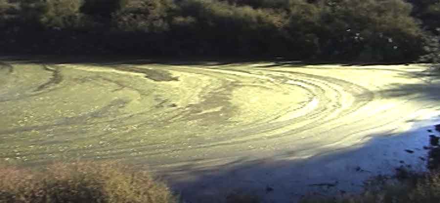
Above, right: this mysterious banner image (described by one viewer as looking like "a galactic cluster in deep space from the Hubble Telescope") was a view taken at sunrise on October 30, 2000, when High Tank flood waters were at their peak, showing a swirling algae foam (which receded rapidly as the day progressed). This foam may have been a result of the runoff having come from the drainage area that had been prescribe-burned in May of that year, producing waters rich in organic materials. Click on the banner image for an enlarged image of the pond.
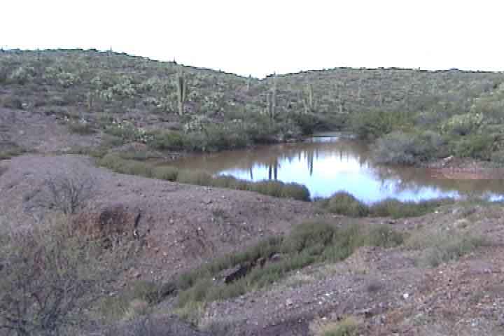
Below: the High Tank, September 2000 after the first rains, viewed from the hill upstream from the dam -- note the low level of water at the base of the new tank:

Below: (now viewed from the downstream side) the High Tank after the big October 2000 rains -- the incipient spillway gullying that is so alarming is visible in the foreground of the left photo. In the center photo, the spillway is located almost at dead center of the shot (but obscured by a low line of tumbleweed). It is surely one more substantial rainfall away from being blown out. On the right, we discuss the potential disaster. (Click on each image to enlarge it.)
 ..
.. ..
..
Our initial work began when we understood the situation, first by removing tumbleweed at the site of the erosions (but leaving tumbleweeds right at the waterline), below, left & center, and filling in the gulleys created by the overflows during the previous week (which ended just feet short of connecting up directly with the pond waters). We then tamped down the replacement fill at the lip by running a vehicle back and forth along it. (Click on each image to enlarge it.)
 ..
.. ..
..
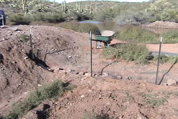
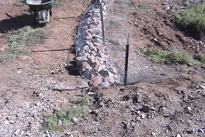
We then constructed an "emergency gabion" just below the tamped soil, to slow any flooding that might occur in the immediate future. We first dug a trench, "keying" it into the walls of the spillway, and laid a layer of chicken wire, into which we drove T-posts at intervals. See below cemter, where Pat Corbett stands beside the wire. Our reasoning for both the size of the gabion and the depth of the T-posts was that the overflowing waters would not have a high energy here, so the T-posts did not need to be driven in deeply. On the left, rocks are being placed into the ditch above the chicken wire base, and at right you see the completed gabion, with the wire both upstream and downstream have been wired together and to the T-posts. We laid additional wire downstream from the gabion, planning to put more fill into that space and tamp it as best we could. (Click on each image to enlarge it.)
 ..
.. ..
..
Below, left: The completed emergency gabion. With more labor on hand during the following week, we began building a series of larger gabions down the slope of the spillway, aiming to create a step-terrace effect. This necessitated bringing in much more rock from the washes far downstream -- see below center and right:
 ..
.. ..
..
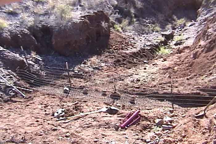
Because we were now dealing with a steeper slope, and needed to have the subsequent, lower gabions considerably larger and more durable than the one resulting from our initial act of desperation, so we brought in much heavier-gauge wire and we also keyed these gabions in better to both sides of the spillway cut (below left, from upstream), and drove the stabilizing T-posts as far into the spillway base as possible, weaving the heavy wire into them . David Omick and Tom Orum are shown (middle, from downstream) as we began filling this trough-shaped wire container with rocks, below right: (Click on each image to enlarge it.)
 ..
.. ..
..
Once we had the trough as full as it could be and still allow its closure, we sealed the gabion with wire: below, left; and went on to the next one. Arni Sveinsson (below, center) carried some very large rocks to anchor these big gabions. The final product of four gabions, plus an additional rock wedge at the bottom (not in view) can be seen in the photo to the right, below. Click on the two right-hand images to enlarge them.
 ..
.. ..
..
As the weather turned out beginning in November 2000, the spillway was not again tested at all during the ensuing year, but we felt reasonably confident that it will serve to produce a terracing of runoff during those occasional events when the High Tank does overflow. As a hedge against a really large rain event in the High Tank Watershed, we could probably use some additional rock-shoring of each gabion where it meets the sides of the spillway, and, of course, rock wedges in the entire drainage area above the tank would be the ideal complement. But labor shortage is a chronic condition in the Saguaro-Juniper world.
Over a period of several years since the above work was completed, this spillway has gradually filled with vegetation, without any further occasion of overflow. First, shown below, a photo from July 2003: (click on the image to enlarge it.)

Second, below, a visit in January 2005. All of the terrace filling you see here has come in from the sides. The tank has seldom contained any water since the big flood of October 2000, and then only in tiny amounts. (click on the image to enlarge it.)

Reviewing our rain history for the time since (we think) this tank first blew out, conveniently the Elliott Weather Station several miles to the west has been in operation since 1983, the year of the Big Flood (which brought such massive destruction to Hot Springs Canyon and its vegetation, as well as to Tucson and other parts of southeast Arizona). In October, the definitive month of that deluge, Elliott's received 6.42", while in October of 2000 it received 5.92", rather close to the iconic total of 1983. In all the years after 1983 through 2005 (with this one exception), Elliott's has never registered as much as 2 inches during the month of October, and since 2001 none of the other winter rain months has come anywhere near this total. Since 2000, all of our Saguaro Juniper winter rains have been below normal (see our Rain Gauge Updates page). Only Elliott's summer rainfall months show totals occasionally comparable to the 6-inch level, and these rains of course tend to be much more localized than those occurring in winter. [This addendum registered in April 2006.]
For the history of the High Tank's construction, see this link: The High Tank. For more information about constructing small Rock Wedges in our minor washes, see that link