
The Diversion Tank (and its Secondary Tank)
The Diversion Tank lies along the right bank of middle Pool Wash (that portion which lies above the confluence with the Big Tank Wash near the windmill at the top of Lower Pool Wash), in a stretch of that wash where the stream gradient is low. In the aerial photograph above, taken by Lynn Smith-Lovin on August 28, 2006 and looking toward the south, the green stripe at upper left marks the entrance of the diversion channel, while Pool Wash proper runs from just above it across the upper quarter of the image, curving to the middle where it exits at far right. The wash has several braidings along this stretch. The map below shows the Tank, with its secondary subsidiary, at map-center, with the Pool Wash Ridge Road roughly paralleling the wash.

Ranchers in the middle of the past century constructed a long earth berm extending out into the wash, in order to divert its occasional floods into a substantial earthen tank they built there. Eventually this tank filled with silt, which gradually backed up into the wash until the berm was ruptured by flood runoff, and the wash then bypassed the tank. By the time Saguaro Juniper Corporation acquired this land, the Diversion Tank had the appearance of a circular grassy meadow (right-center below), gaining its rain runoff only from its own flanks. Below left, this view from the Pool Wash Ridge Road (elevation point 3815 on the map above), shows the main wash route at lower right and far left, with the enclosing berm lost beneath a wide encircling growth of mesquite trees; below right, a view from upstream in May 1995 looking out toward the encircling embankment with its array of trees. The Tank had become an occasional catchment, displaying the green of fresh Bermuda Grass after rains. (Click on each image to enlarge it.)
 ..
..
From the old entry point of the old Tank, one could see its archaeological remains, where the wash had cut through the old diversion berm, as well as the silt build-up which had filled the entry channel to foster the cut. Below Left, the old diversion berm in May 1995, at the point where it had been cut by main wash floods; in the Middle, the old berm -- now shown on the left, with the built-up silt infill on the right, a paler, grayer color than the berm; on the Right, in July 1998 just before we rebuilt the dam, in a view from further upstream, Tom Orum stands on the old silt fill, now well above the lie of the wash (which flows from lower right to upper left, belying the appearance in the photograph). (Click on each image to enlarge it.)
 ..
.. ..
..
In 1998, Saguaro Juniper Corporation planned and proceeded to rebuild the Diversion Tank (and also its Secondary Tank just uphill from it, see further below). Below left: the old center of the Tank before reconstruction began; Right: Jim Corbett discussing Tank reconstruction with Don Decker (at near left) and other agents of the U.S. Natural Resources Conservation Service. (Click on each image to enlarge it.)
 ...
...
Farron Bingham built the new Diversion Tank with his bulldozer in August 1998. Below left, the new Diversion Tank viewed from the Ridge Road; note that the builder spared a number of the flanking mesquite trees while rebuilding the berm. Middle: the central basin viewed from the tank end of the berm, with the entry channel directly opposite the viewer at right-center; Right: the new diversion berm from the point of entrance, on the left, the new entry channel below it on the right. (Again, note the mesquite trees lining the upstream edge of the berm at this point.) (Click on each image to enlarge it.)
 ...
... ...
...
The Secondary Tank was also rebuilt. The panoramic image below (from April 2002) shows the main Diversion Tank at lower left, with its clear bowl shape ringed with dry Bermuda Grass. A horizontal line running from the bowl across the lower center of the image marks the entry channel, while a second bowl may be seen at a somewhat higher elevation at top-center in the lower-righthand quadrant of the image -- this marks the location of the Secondary Tank. Note the contrast in color evident above this Tank -- whitish hills, composed mainly of pale gray, fine-grained Galiuro Volcanics alluvium, which marks the very small drainage serving it. (Click on the image for a closer view of the Secondary Tank.)

Since the time of its reconstruction, the Diversion Tank has filled every time that Pool Wash runs with any degree of vigor. In July 1999, the tank filled, and in October, 1999, we put a layer of Bentonite over the basin, hoping to slow out-seepage. Below left: the Diversion Tank seen from the Ridge Road, November 2000; Middle and Right: seen in August 2001, from the entry channel and from the Ridge Road. In all these photographs, the water is backed up from the central basin some distance into the entry channel.
 ..
.. ..
..
In September 2002, we received powerful rains that filled the Diversion Tank to the brim. Below left, a view from the south; below right, from the east. You can see from the right-hand image that the tank is full all the way to the intake to the diversion channel. (Click on each image to enlarge it.)
 ..
..
However, this pond sank rather rapidly, and stood mostly empty for two years thereafter, due to lack of wash-running rains. Here is a view below from April 2004:
The drought broke in August 2004, and the main tank filled fairly full again. Here is a view of the much smaller, Secondary Tank from that month: (Click on the image to enlarge it.)

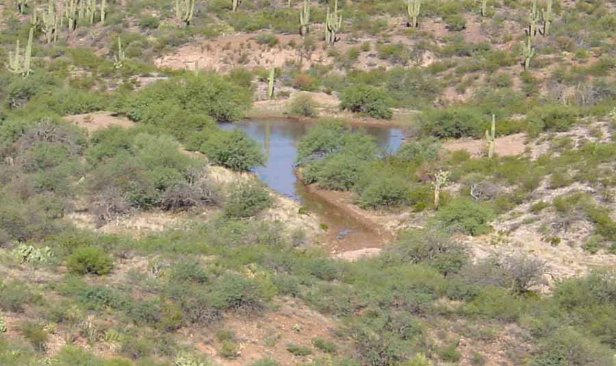
However, neither tank held water very well, and (again following years of drought) subsequent gullywashing rains in the summer of 2006 filled the Diversion Tank full, but it again leaked out rapidly, with visible flow running down the adjacent wash. It seems probable that this leak is facilitated by the root structures of the large mesquite trees left standing on the downstream side of the berm when the tank was rebuilt (though faulty bentonite-laying techniques also cannot be ruled out; however, this was the final watertank we bentonited, and we increased the density of Bentonite put into the floor of the basin).
We're sad about the loss of water, since the area around this tank is good grazing land and presence of water attracts many varieties of wildlife. Clearly we confront a land of very unpredictable rainfall (see Weather link) and endlessly dynamic erosion, and we are learning to temper our optimisms concerning the effectiveness of our work with the recognition that our efforts are in the long run limited and perhaps ephemeral here.