Ecoregion Definition: Distribution of Type-defining Plants
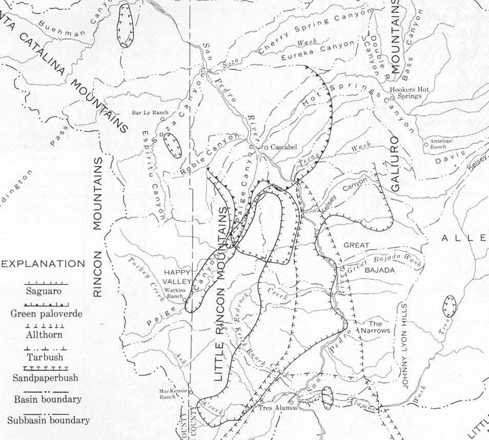
According to all of our authorities, the defining plants of our Arizona Uplands Series of the Sonoran Desert are primarily the Saguaro columnar cactus and the Foothills (Green) Palo Verde. Zimmerman's (1969) map of plant distributions (which corresponds well with our own observations for the most part) shows both of these diagnostic types reaching well to the south and east of Cascabel (shown just right of upper-center in the portion of Zimmerman's map presented below). (Zimmerman's map shows Saguaro distribution running south even beyond the Narrows on the West side of the San Pedro River, a pattern which does occur on some slopes there.)
In Hot Springs Canyon (directly northeast of Cascabel), a striking contrast appears between the south-facing and north-facing slopes of the canyon. The south-facing slope is a near "forest" of Saguaro cacti:

Similarly, just upstream from this location, Palo Verde is very common: (the yellow blossoms are Foothills Palo Verde blooming in May of 2001):
In contrast, the plants generally regarded as type-specimens of the Chihuahuan Desert include the Tarbush and Sandpaper Bush, but Zimmerman shows neither of these occuring in the vicinity of Cascabel. Zimmerman's map shows the northern limits of Tarbush to be well south of the Benson Narrows, just north of Tres Alamos Wash, while Sandpaperbush is shown to extend northward on the edge of the Little Rincon Mountains west of Kelsey Canyon Wash and Teran Wash (and further northwest near Soza Canyon Wash and Buehman Canyon Wash), but not to our immediate area.
Actually, however, we have seen both of these plants in our area around Cascabel, though they are quite rare, and the Tarbush plants in particular look to be considerably stressed (see the link above for images). An additional plant worth mentioning, which is clearly associated with San Pedro drainage locations south from Cascabel (and especially common in the terraces and washes around Benson) and is often characterised as a Chihuahuan Desert plant, is Yucca elata. We find this very common in the lower reaches of our San Pedro River tributaries (but not on our uplands, where Yucca baccata becomes the dominant Nolina).
Also, both Saguaro and Foothills Paloverde plants decline quickly as one moves southward (upstream along the San Pedro River) from Cascabel, so an ecological boundary to "Arizona Uplands" is definitely reached near Teran Wash and Kelsey Canyon. So what we are seeing is that the boundary of the Arizona Uplands extends considerably further south than it was drawn by Shreve in the 1950s or by later researchers, and yet Chihuahuan Desert plants do also reach northward into Cascabel. In vegetational terms, we are definitely occupying a "Transitional Zone" between the two Ecoregions, but one that looks to be "tipping" in the warmer direction of the Arizona Uplands Series of the Sonoran Desert.
For further elaboration on the subject of Saguaro-Palo Verde vegetational associations as we find them near Cascabel, see Arizona Uplands, Part (3), and San Pedro River Valley Flora Today.
Another contrast between Sonoran and Chihuahuan Desert plants has been drawn by Brown & Lowe comparing the different varieties of Creosotebush found in the two regions. See this link -- Chihuahuan vs Sonoran Creosotebush for a brief consideration of this contrast.