Notch Ridge and Notch Basin
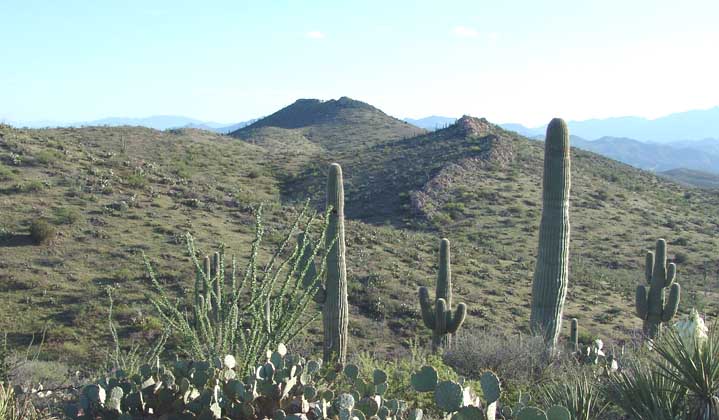
In the photo below taken in March 2003, looking toward the East, the Notch (or "Backbone") Ridge runs roughly from the Southwest (toward the right) to the Northeast (at far left), beginning just off the Northwest flank of Sierra Blanca, which is out of view to the far right in this photo below. In the banner photo above taken in May 2004, now looking toward the Northwest, the Notch separates the two unequal halves of this ridge, while beyond lie Saguaro Juniper hills and far beyond, the Catalina Mountains. A small portion of the Notch Basin is just visible at dead low-center of the photo below, with its array of saguaros behind the Ridge. In the farthest distance, beyond the sunlit conical hill, you can see the dark blue of the Winchester Mountains on the horizon to the East.

The Notch Ridge is a strip of Galiuro Volcanics (aged less than 28 MYA) igneous rocks which intruded into the older Cascabel Formation (aged 65 MYA), during the "Tertiary Orogeny" of mountain building that included the formation of Sierra Blanca. For more information on the geology of this area, see Geology: Pool Wash to NE Corner. This Ridge, as well as Sierra Blanca and the surrounding uplands, originally formed an enclosed basin as roughly outlined by the green dots marked on the aerial photograph shown below, looking roughly ESE, with the Notch in the lower central foreground and Sierra Blanca just out of view to the right:

Over time, the basin was gradually breached, forming the Notch, visible in the lower-center of the aerial photo above. The Notch now forms a deep, shaded, cool defile, where you see hikers climbing through it in November of 1994, below left. It is just out of view in the photo below right, taken in March 2004 from the far southeastern edge of the basin, with the descending flank of Sierra Blanca visible far-left center. You can see from the right-hand image why the ridge might be called the "Backbone" Ridge, of a giant snake.
Click on each image to enlarge it.
 ..
..
Below, viewing the Notch in May 2004 from a ways upstream shows the rich arboreal vegetation, with a number of juniper trees in the mix.

Viewed from the north end of the basin, below, you can see that the basin's north-side wash runs at a very low gradient toward the south (away from the camera position near the top of the basin), while the slope dropping down toward the center from Sierra Blanca, at upper left, is very substantially steeper. Nonetheless, this basin is a protected space, where we have found construction of rock wedges a valuable tool for slowing erosion. In the page reached through the link just indicated, the bottom four wedge examples illustrated are located in the Notch Basin.

Viewed below from a considerable distance to the north, the Notch Ridge (middle right in the photo, taken in April 2004) shows a sinuosity at its northern end Sierra Blanca is the dead center monument in the distance. The northern rim of the Basin lies beyond the saddle that swings across the picture immediately above the tip of the central saguaro in this photograph. Click on the image for a closer view.

This volcanic-ridge-and-basin place is very interesting, ecologically speaking. Within the perimeter of the basin, during certain weather regimes, we have seen remarkable plant flowerings, for example on a southern (north-facing) slope below left in October of 2001; outside that perimeter, along the north-facing flanks of the north side of the Notch Ridge, we have seen some unusual plants growing in protected locations, for example, below right (from April 2004).
 ..
..
The rocky cliffs of the Ridge work to channel and concentrate moisture, resulting in some unusual plant formations. Below left, a cross-section view of the Ridge from a point near the Notch (note the Juniper shrub growing right out of the top of the formation); below right, a close-up of the northern end of the Ridge in April 2004, with some of its distinctive vegetation. The tree growing in the base of the Ridge in the right-hand image has been identified as a Texas Mulberry -- not at all a common tree in our area, and generally found near water sources where it grows in semiarid zones. Click on each image to enlarge it.
 ..
..
Below, a view looking upward toward the Ridge from the Northwest, showing the rich carpet of annuals and scattered perennial grasses on the slope, greening up in April after the good Spring rains of 2004. The ridge is largely concealed by the mesquite trees growing in the middle distance:
