The Santa Catalina Mountains
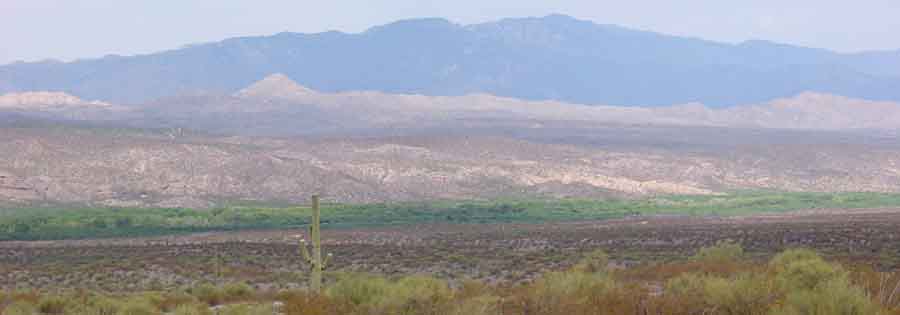
While the Santa Catalina Mountains appear for the most part visually remote to us from our main locations near the San Pedro River and Hot Springs Canyon confluence, they are one of the four major Sky Island mountain complexes with which Saguaro Juniper lands are ecologically very closely linked -- the Rincons, the Galiuros, and the Winchesters are the other three: Our drainage corridors connect us intimately with all four of these "Sky Islands", and many kinds of wildlife move between them. Above, the Catalinas loom in dark blue above the San Pedro River Valley in July of 2002, viewed from one of the lower fingers of Soza Mesa. Old river terraces and foothills of Redington Pass (called Cebedilla Pass during the 19th century) rise beyond the "Ribbon of Green". The Redington Pass road runs out of sight from far middle right of the photo, crossing in front of the base of Piety Hill (the sharp bright conical form standing out at middle left in the photo) on its way over the saddle at far left. Piety Hill is a significant landmark along this old commercial road that links the Middle San Pedro valley with Tucson.
For map guidance concerning locations discussed here, see the bottom of this page.
The Catalinas are part of the Coronado National Forest and also include the Pusch Ridge Wilderness Area. The mountain range is one of the most prominent of the Madrean sky islands. Pioneer plant ecologist Forrest Shreve undertook the task of defining Sky Island vegetation zones in these mountains during the first decade of the twentieth century, and you can see some results of his work and the later efforts of R.H. Whittaker & W.A. Niering and others in the following link: From Desert to Sky Island Vegetation.
Below, the peaks of Mount Bigelow are obscured in clouds at 8 AM on January 7, 2008 in this photo taken from the Pool Wash ridge road, high above south-facing slopes of Hot Springs Canyon which are emerging in the predawn light in the foreground. In this winter dawn image, Piety Hill stands in bold shadow a bit right of mid-photo, while first dawn light hits the montane canyon behind it. Click on the image to enlarge it.

This image below of Mount Bigelow (the peak near dead center ) was taken from Cascabel Road near Hot Springs Canyon (with 10X zoom) on February 22, 2008 as early morning light hit the lower flank of the mountain. Click on the image to enlarge it, for a clear view of the radio antennae perching atop the peak. Note snow on the north side of the mountain, typical for this time of year.

Below, sunset over Redington Pass, taken from Lynn and Miller's airstrip above lower Hot Springs Canyon September 9, 2003. The southern flanks of the Catalinas rise along the horizon at lower right. Click on the image to enlarge it.

Below, a view of fire in the Catalinas in May 2002:
![]()
For info on the June 2003 Bullock and Aspen Fire, see this link.
Below left: Redington Pass Cloudscape winter 2000; Below right: Catalinas cloudburst over the Redington Pass Road, August 4, 2001
![]() ..
..![]()
Below: images of Catalina fire of June 2003 at sunset, and by daylight:
 ..
..
Below: Redington Pass sunset, 2 days before Spring Equinox 2003; Catalinas on the right, Mica Mtn on the left:

Below: tranquil Catalinas viewed from Soza Mesa, March 2003:

For geological discussion of the Catalina Mountains, click on Geology Walk: Metamorphic Core Complexes....

