
Geology Trip: Teran Wash to the Red Tank

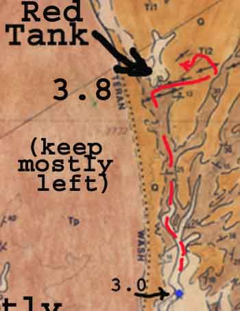
Note: this trip may be aided if we consult the Supplemental Map to the left (derived from Goodlin & Mark, in Credits & Bibliography)
Click on the image to the left to enlarge it.
for this map, the keys are:
Q = Quaternary
Tp = Paige (San Manuel) formation (gray conglomerate)
Tm2 = Mineta Limestone (mostly reddish)
Tm1 = Mineta Conglomerate (mostly reddish)
Ti1 = Tertiary dike swarm, basaltic andesite
Ti2 = Tertiary dike swarm, “turkey track” andesite porphyry
We enter Teran Wash via the Green Gate located just west of the intersection of the wash with Cascabel Road (just beyond Milepost 20). Only 4WD should attempt this trip.
Set speedometer to Zero; remember that the mileage numbers indicated below will vary somewhat depending on vehicle size.
Note the Map Supplement links placed at various points in the trip.
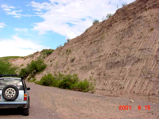
At first the wash is very wide, with many braids, running first straight North (for .4 mile), then sharp E and then NE when you can go no further E.. At Mile .9, the wash flanks a high wall of pale reddish, unconsolidated Quaternary Alluvium, the characteristic flanking formations in the lower wash. Usually, tire tracks will guide you up the wash past this point; but here you turn away from the cliffside wash and angle somewhat leftward, then you tend to keep to the right.

At about Mile 1.6, the wash narrows abruptly as you encounter the weakly cemented but distinctly tilted Paige Gravels [Tp]. In Hot Springs Canyon, these are called San Manuel Formation), which is gray in color due partly to volcanic ash-fall contents in the sediments, as in Hot springs Canyon, but here it has a more strongly greenish cast:
 This faint green tinge -- more evident in some conditions of lighting than in others -- is due to minerals contained in the granodiorite cobbles and boulders, which originated as part of a great pluton below what are now the Johnny Lyon Hills some 1.65 Billion years ago, later raised from many kilometers down, but then eroded by the washes flowing in San Manuel times (Lower Miocene, 22-15 Million YA):
Bearing to the left at each major branching of the wash, we continue in a curving but roughly easterly route through these tilted gray Paige or San Manuel sediments, until at about Mile 2.2 we encounter a major fork, still seeing the gray sediments. Here, bear left:
A short ways further on, we see rather bright reddish formations ahead, and take a major left fork in the wash, at Mile 2.6. The map supplement just below traces in a red line the route direction.
Here is the decision-point: below center, the road fork -- you can see a reddish hill behind the trees; right, the wrong way (pointing toward the Teran Cliffs); left, the correct fork, which points toward the Red Peaks:
 .
. .
. .
.

We now begin to drive in a more northerly direction, placing these red formations to our right. These are part of the Mineta Formation [Tm]. This Formation is more than 28 million years old in some places, but may be Miocene (22 million YA) in others, and has been tilted by various low-angle normal faults (including the Teran Wash Fault, which runs out of view from North to South just to the West of our North-South- running wash). A short distance further, we can see (at left) an Intrusion of Tertiary Basaltic Andesite into the hill of Mineta Formation:
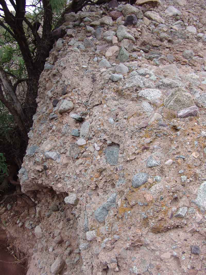
Below are some more detailed images of this Intrusion and its margins. It is also our banner photo shown at the top of the page.
 ..
..
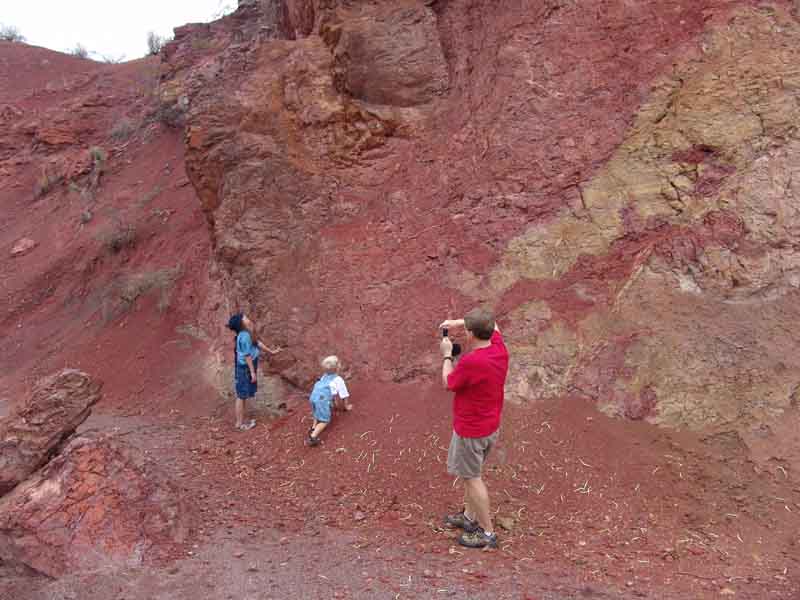
The Mineta Formation has other complexities, including volcanic deposits and dikes of various ages and in various places, but there are two major divisions of its sedimentary formation. First, above Mile 2.6 we enter a zone of Mineta Limestone ["Tm2"] Formation, largely the result of sedimentary deposits in large lakes of the region, perhaps 30 Mya. [Beige color on the map supplement.] These lakebed deposits vary widely in colors, from fairly dark red to orange to yellowish to dull gray to steel blue, and all are strongly tilted from their original horizontal positions, as shown here, Mile 2.9:

Shortly above this point, at Mile 3.0, we encounter a very striking exposure of two thick orange lakebed strata, with multiple beds of darker color above and below. This is a site of considerable geological interest.

As we head North in this wash (but note: in this image, the vehicle is pointed South), we can see along the hills rising above us to the West the gray San Manuel Formation lying unconformably atop the Mineta Formation, which is here composed of claystone (?) deposits:
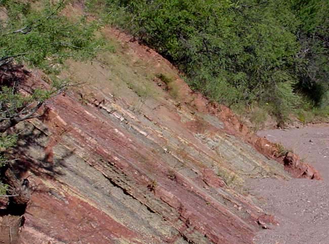
 By Mile 3.3, we encounter beds of the second major Mineta Formation Member, the Mineta Conglomerates [Tm1]. These are later in age than the limestones (perhaps 28-22 Mya), and are more reddish-brown in color. On the map supplement, they are shown in dark brown:
Note on the map how you keep left (and northward) at the major wash intersections here.

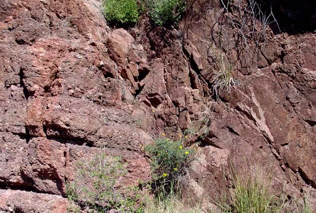
At Mile 3.5, a teriary Basalt dike cuts vertically through these Mineta Conglomerates, as shown at left. Note in the close-up how burned and altered are the conglomerates proximate to the dike. Note on the map supplement the indication of this dike, shortly before the turn up to the Saguaro Juniper gate.
Swarms of such dikes also predating the Galiuro Volcanics (which we can now see prominently exposed well off to our NE, on the ridges of Sierra Blanca) are scattered in the hills along this wash and to the East.

Finally, when we climb out of the wash toward the Saguaro-Juniper gate at 3.6 miles, we see to our North a wall of reddish-purple rock, topped with saguaros:
This wall, which lies just downstream from the Red Tank, is composed of two contrasting formations on the left and right:

on the left, Mineta Conglomerate, perhaps 27 Million Y old:
 on the right, “Turkey-track” andesite porphyry, product of an intrusive volcanic dike older than the Galiuro volcanics but intrusive into the Mineta Conglomerate:
This rock tells Arizona geologists that a very early Galiuro Volcanics was involved -- about 25 MYa. The "turkey tracks" are crystals of Feldspar that started to form while the magma was still flowing, while the rest of the rock did not crystalize. This rock type is very distinctive in this part of Arizona. The location of this dike is also shown on the map supplement.
Click HERE for a Turkey-track closeup.
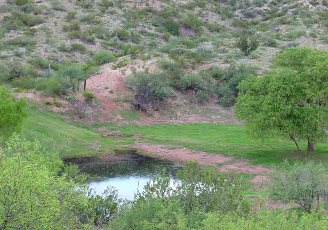
Most of the drainage slopes located to the East and North, which fill the Red Tank with most of its water, are composed of a reddish Quaternary calcite-cemented “Pediment Gravel”, which overlies the earlier Mineta Conglomerate Formation. This calcite cement (Calcium Carbonate, or Limestone) is soluble in acids, which may be the reason the Red Tank waters are usually so clear. This photo was taken in August 2001.
For a summary placing the Teran Wash processes in their wider historical context, see Meader: Geological History of our Area.
Return to Geology Home Page