
Hot Springs Wash and Canyon
As you go up the Hot Springs Wash from the Windmill toward the Rabbit Ears Saguaro Hill (and our deeded land fence and gate), you walk along the low silty and gravelly terraces of the floodplain, which is stream alluvium being deposited during Pleistocene to recent times (the Quaternary Period, here much less than 1 million years old). Note the wide variety of cobble-to-boulder water-worn clasts lying scattered amidst the sands and silts of the floodplain. These have eroded from diverse rock formations located upstream.
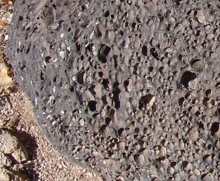 For example, at left, consider one of the many blackish, rounded river cobbles, some quite large, each densely vesicular (filled with many small holes, formed by gases contained in the volcanic magma as it cooled). These are basalt rocks eroded from a lava flow some millions of years ago the remains of which are found far to the northeast of our area, on the east side of the East Range of the Galiuros (see Galiuro Mountains), near the headwaters of Bass Creek (a major tributary of Hot Springs Canyon), located to the south of Bassett Peak. These large river cobbles are common in our Hot Springs Canyon floodplains because basalt is composed of tightly interlocking crystals that resist the poundings of waterflow, hence the rocks retain their coherence over long distances as they are gradually borne downstream.
Click on images for a close-up view.
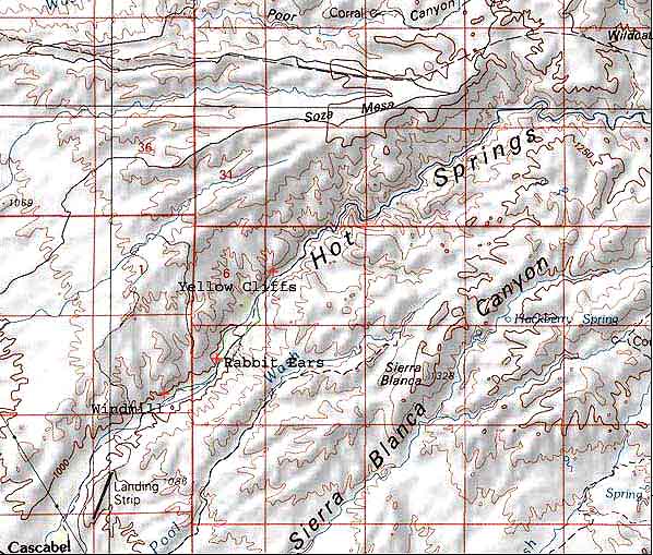
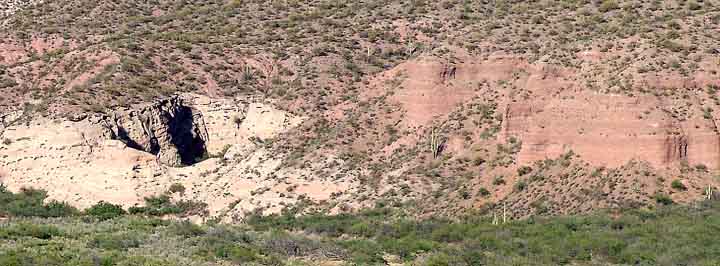
The widely separated canyon walls present a different appearance from these black rocks in the alluvium: Two characteristic cliff formations flank both sides of the lower canyon at and near the Rabbit Ears Saguaro Hill. (For map orientation, see Hot Springs Canyon Map.)
The Quiburis and San Manuel Formations
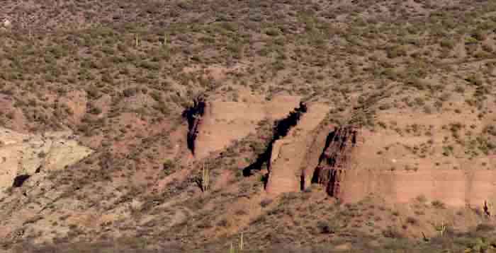
First, beginning well downstream from the Windmill, one sees fairly smooth, vertical-sided, reddish-brown walls of pebble-to-cobble conglomerate sediments, high up on the flanks. These are the most recent of the older Cenozoic (Tertiary Period) formations in the canyon, and are called the Quiburis Formation (massive beds of fairly fine alluvium deposited in the San Pedro basin trough from sources in the great Galiuro fault-block mountains to the east, during late Miocene to early Pliocene times, about 7 to 5 million years ago). These sedimentary rock strata lie in a characteristically very gradual slope, at the tilt of their original deposition. Most of Soza Mesa, for example, is composed of this formation -- it is the remnant of a great alluvial fan (bajada) built from debris eroding out of the Galiuros when they were much higher in elevation. (See also More Recent Formations.)
Below, a photograph of Henderson Cliffs on the right bank of lower Hot Springs Canyon in February 2008. This Quiburis outcrop is a southwestern distall tip of one of Soza Mesa's many outstretching fingers.

In this much closer image below, you can see interbedded layering of gravels and more clayey-silt deposits, lying as they were deposited during the alluvial construction of the great Soza Mesa bajada prior to 5 Million years ago.

Below you can see the inter-layering of clays and gravels at even closer detail:

On the map below, the Henderson Cliffs point southwestward at the far lower left corner of the image. Other pertinent landmarks for the following description are indicated as well.
Second, just across the wash from Rabbit Ears Hill appear large outcroppings of an older Tertiary sedimentary formation, which underlies the Quiburis (as can be seen on both the east side of the canyon near Rabbit Ears Saguaro Hill and the west side further upstream toward the Cleft). These cliffsides are more sloping than vertical in shape (almost domelike in shape), mostly pale gray in color, with many small cave-holes. This is the San Manuel Formation -- a coarser, looser conglomerate mix of rougher pebble-to-boulder alluvium, and in part containing the volcanic tuff and ash produced during the earlier Galiuro volcanic mountain-formation to the east. It is much more strongly tilted than the later Quiburis complex which overlies it. In both images below, the contrast between pale (if somewhat striped) San Manuel Formation beneath and the sharply reddish Quiburis above it is clear.
 ..
..
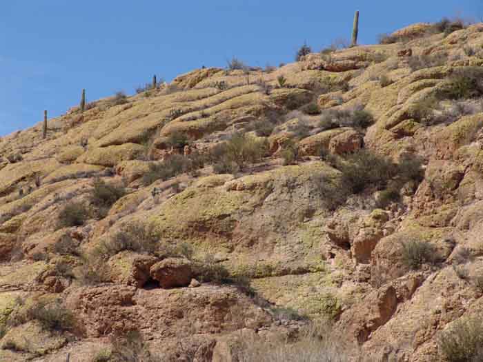
This sharper tilting of the entire formation reflects the mountain-formation fault-block processes that occurred in the Galiuro region mostly after these San Manuel rocks were laid down. Though mainly sedimentary, the San Manuel formation includes some air-fall volcanic ash in places, and dates to lower Miocene times (from 22 to no later than 15 million years ago, when the major block-faulting began). Our whitish "cleft" near the yellow cliffs, and our "meditation" place across the wash from Rabbit Ears, display the quality of this remarkable formation very strikingly, including its tendency to produce very deep, narrow clefts during very rapid erosion.

The image below summarizes the relationship between the San Manuel and Quiburis Formations. The photo was taken from across the canyon and downstream, looking northeast past the Windmill (visible in the lower-left foreground of the photo). For a close-up of the San Manuel Formation portion of the photo, see this Link. For a close-up of the Quiburis Formation portion, see this Link. Click on the image below for a close-up view.
Note the horizontal disposition of the dark-red Quiburis Formation on the right, and the strong tilt of the grayish San Manuel Formation downward toward the West. (See also Basin-Range.) Note also how the Quiburis Formation extends over the top of the San Manuel. In conformity with their differing consolidation, the San Manuel beds (less strongly bonded together) erode at a sloping angle, while the Quiburis (more strongly bonded) erode more vertically.
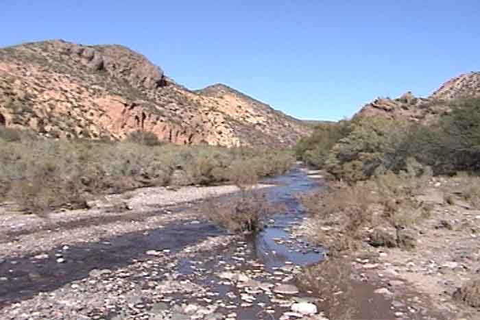
The pale vegetation in the canyon bottom shows where the 1991 and 1993 floods scoured the floodplain clean.
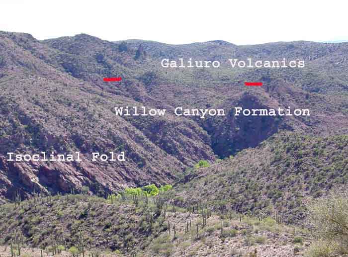
Teran Wash Fault and the Galiuro Volcanics Formation
As you proceed further upstream, precisely where the Yellow Cliffs mark the mouth entrance into Hot Springs Canyon narrows, a long low angle normal fault, the Teran Wash Fault, crosses the canyon running from NW to SE.
The Teran Wash Fault is seen more clearly from the air, as below:

In this image, an almost straight, pale line (divided in the middle by the wash), running from the center of the photo somewhat diagonally into the lower right quadrant, coincides roughly with the line of the Fault (also marked by the two red dashes for clarity). The Galiuro Volcanics extend above it in the upper right quadrant of the photo. The San Manuel Formations exposed in HSC also show up clearly here, in the pale gray cliffs framing the wash around the central parts of the picture. (Thanks to Lynn Smith-Lovin and Miller McPherson for the airplane ride!)
The Map below (adapted from Goodlin 1985 and Mark 1987, see Credits & Bibliography) shows the divisions clearly (click on the image to enlarge it) -- the Quaternary alluvium is shown in yellow, the San Manuel outcroppings [Tsm] in brown, the Quiburis overlying formation in beige, and the Galiuro Volcanics in pink. The Fault is faintly marked with a hard black line where directly visible, with a dashed line where it is buried under the alluvium.

The straightaway side-wash running into the main wash from the NW at this point marks that line of this fault, downward movement along which (occurring less than 20 MYa) has juxtaposed the younger (and formerly higher) San Manuel Formation beside some of the older Galiuro Volcanics, of which theYellow Cliffs and their counterparts across the canyon to the east are a part. Below left, the Yellow Cliffs stand on the left (and less conspicuously, on the right) beside the Hot Springs Canyon stream. Below right, geologist Mick Meader points northwestwardup the Teran Wash Fault, with the Yellow Cliffs on the right and the San Manuel Formation on the left.
 ..
..
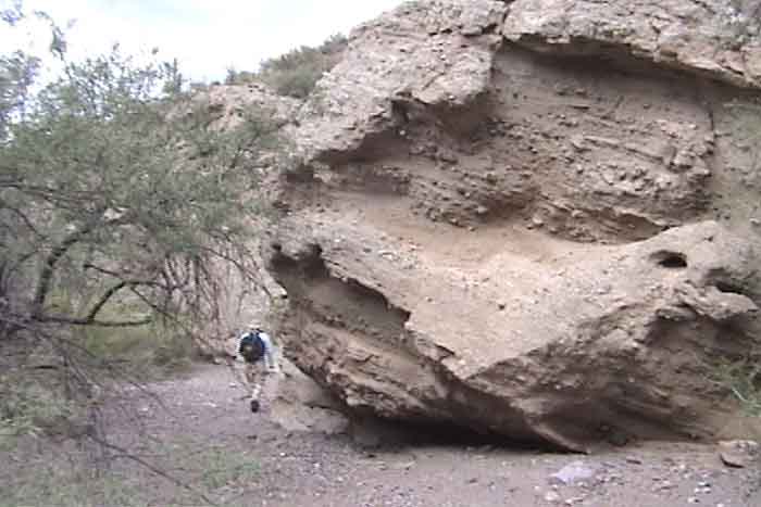
The Teran Wash Fault that marks this NW-SE-running side wash has some remarkable features, including (Below left) this apparently detached, massive, boulder-like San Manuel rock. Below right, the Yellow Cliffs are not really yellow insofar as their rocks are concerned -- the "Yellow" is produced by the kind of lichens growing on south-facing sides.
 ..
..
The image below gives some indication of the layering of different volcanic flows discernible in the Yellow Cliffs as you approach the narrowing gap.

The Galiuro Volcanics include more purplish and reddish cliffs lining the narrows a short ways upstream from the fault at the Yellow Cliffs, and display varied kinds of volcanic rocks including basaltic andesite, rhyolite, and "turkey track" andesite porphyry.

Part of the same complex of volcanism which produced the mountain rocks of the Galiuros to the East (and several other volcanic formations in Southeast Arizona at the same time), these rocks erupted in late Oligocene times, around 29-24 million years ago -- the time of the Mid-Tertiary Orogeny (mountain formation) associated with eruption of the andesitic lava- and tuff-layers now exposed as the massive cliffs of the Galiuro escarpment which form the backdrop rising behind and above Soza Mesa itself. See The Galiuro Mountains for views. See also this geological link: metamorphic core complexes.
Below, the map indicates the locations of features now being considered:

Soza Mesa Fault and the Willow Canyon Formation
As we proceed northeastward into the canyon narrows, the walls on both sides are Galiuro Volcanics until we reach a point just above the entry of the Red Trail (and which is, perhaps significantly, about the point where the "normal" ending of perennial stream flow occurs). Here, another major fault crosses the canyon: the Soza Mesa Fault, a mid-Tertiary (less than 24 MYa) low-angle fault -- apparently, a Detachment Fault -- which marks the upper end of the Galiuro Volcanics at this point and the beginning -- at first, just along the canyon flanks -- of a much older formation, the Willow Canyon Formation of the Upper Jurassic-Lower Cretaceous Bisbee Group (so named after an outcropping of the same kinds of rocks near Bisbee, this Hot Springs Canyon location marks its most northerly known occurrence).

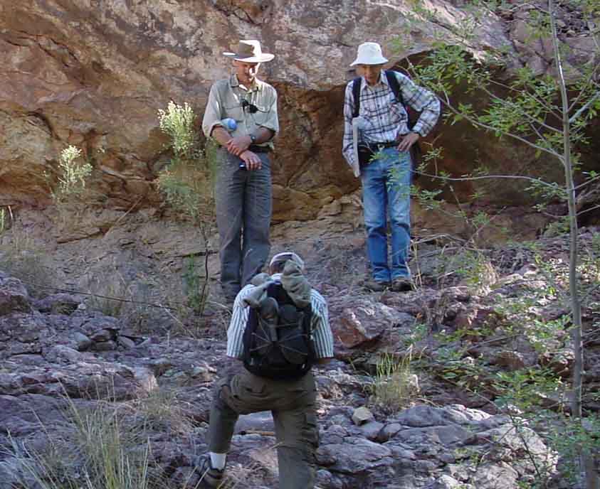
The seminar group here is seated on the surface of the fault, with Galiuro Volcanics above and Willow Canyon Formation below. Geology Walk led by Robert Scarborough & Mick Meader, March 17, 2001.
This fault, above, is apparently a major detachment fault, which has moved the overlying Galiuro volcanics several kilometers westward, in a massive "landslide" downward (to the left) over the underlying Willow Canyon formation, the surface of which has been much disturbed by this process. As Bob Scarborough observed while we walked over this surface, "It's all messed up." Here below are two closeups of the boundary:
 ..
..
Especially in the right-hand photo, you can see the clear contrast between the rough-textured, rather amorphous volcanic rock above and the slick, smooth texture of the Willow Canyon mudstone where it is lying in a fairly plane slope sculptured by water flow. Note also in the right-hand image the more reddish color of the Willow Canyon Formation compared with the darker-toned Galiuro Volcanics, also visible in the photo immediately below. See also link: Geology Walk (2) Core Complexes & Detachment Faults.
Here below is the cross-section map provided by Goodlin and Mark (adapted from Goodlin 1985 and Mark 1987, see Credits & Bibliography), centered on the Soza Mesa Fault, also showing the Teran Wash Fault downstream and the next major fault upstream. In the coding, the orange formation is the San Manuel, the pink the Galiuro Volcanics, while Kb denotes the Willow Canyon

Cretaceous Era Formations, continued
Just above the point of the Soza Mesa Fault, and on the right bank in the Hot Springs Canyon streambed, a formation of Cretaceous Intrusive volcanics [Ki] (intruded more than 80 MYa into the Willow Canyon) is exposed. This contains diorite and andesite porphyry. It is nicely visible in the photo below, which was taken from the Red Trail lookout photostation:

In this photo, above, the site of the March 2001 group photo is visible at the lower-right portion of the top-left quadrant of the photo (where the Soza Mesa Fault is clearly visible if somewhat shadowed). Along the stream bed, to the left are gray limbs of the sycamores of upper Coati Terrace, while to the right is the Cretaceous Intrusive Formation (dark gray, beside the stream, Ki), over which are draped the (much older) Willow Canyon Formation (the brightest reds in this photograph; lighter-colored rocks above them are Galiuro volcanics).
The Map below (adapted from Goodlin 1985 and Mark 1987, see Credits & Bibliography) shows the faultline clearly -- again, the Quaternary alluvium (which reaches its most upstream extent at this point) is shown in yellow, the Galiuro Volcanics in pink, and the Cretaceous Intrusive [Ki] in red. The Willow Canyon Formation [Kb] is indicated in green.

Just upstream from the Soza Mesa Fault boundary between the Galiuro Volcanics and Willow Canyon formations, now walking in the canyon floor itself, we leave the Quaternary gravel/silt alluvium of the stream bed and walk upon the small Cretaceous Intrusion of diorite and andesite porphyry (identified above). This is younger than the Willow Canyon formation; Mick Meader suggests it may be a dike or conduit of one of the large stratovolcanos erupting during the Muleshoe Volcanics (which occurred about the time of the Cascabel Formation, see below), or possibly synchronous with the thrust-faulting period just discussed. (See also the cross-section map, B - B', in Hot Springs Canyon X-section). It runs along the canyon about 1/10 of a mile, then gives way to Willow Canyon Formation on the valley floor (and which also fills the canyon sides at this more upstream point).
The map below indicates major reference points for our further discussion. Along the Canyon from the Narrows through the Zig-zag Bend the immediately-visible outcroppings are Willow Canyon Formation.

These torturously twisted and tilted, mostly reddish, stratified rocks of the Willow Canyon Formation line the walls of the canyon from the Red Trail up past The Nature Conservancy fence line and beyond the Zig-Zag Bend (where the canyon bends -- as one walks upstream -- from NE-ward to SW-ward and then NE-ward again over a short distance, first crossing the Nature Conservancy boundary and then re-entering our grazing lease, then crossing the boundary again), running to a point about 0.2 of a mile further upstream, where the oldest fault system in the canyon appears: the Hot Springs Canyon Fault, which marks the Thrust Fault boundary along which the Willow Canyon Formation was pushed upward and mostly outward in an easterly direction for considerable distances (possibly several kilometers) during the early Cenozoic Era, thrusting over a much more recent sedimentary formation of the Cretaceous era, the Cascabel Formation. The interface of these two formations is extremely complex in this vicinity, as you can see from this map below, where the Galiuro Volcanics downstream are shown in pink and the Willow Canyon [Kb] in pale green. The Cascabel Formation [Kc], into and over which the Willow Canyon has been thrust, is shown in yellow in the upper-right quadrant. Hot Springs Canyon runs from the yellow at bottom left (there marking the upstream extent of Quaternary Alluvium) and red (the small Cretaceous Intrusive formation), thence upward and somewhat to the right.

Again, this map is adapted from Goodlin 1985 and Mark 1987, see Credits & Bibliography .
The model below constructs the sequence for this area, each block showing a cross-section with southwest on the right and northeast on the left. This shows the older Willow Canyon Formation (#3) thrusting into and above the later Cascabel Formation (#5). The "Muleshoe Volcanics" stratum (#4) is not present in our portion of Hot Springs Canyon where the thrust-fault is visible. Thanks to Mick Meader for adapting this model.

This over-thrusting is very clearly seen from the Mesas above, here from Soza Mesa looking down into the Canyon, a view which also shows the detachment-fault boundary between Willow Canyon and the more recent Galiuro Volcanics that overlie it, shown in the image below:
 (Click on the image to enlarge it.)
In this image at left, the reddish tones of the Willow Canyon Formation have been somwhat intensified to make the geological boundary between this much older formation and the Galiuro Volcanics that overlie it appear more clearly, though the flat, horizontal division (demarcated here by the two red dashes) is visually clear enough when viewed from the ground. The area where the GV logo is placed is Lower Cottonwood Seeps Basin; the WCF logo is marked at the cliffs above the Zig-Zag bend of Hot Springs Canyon stream. The "Zag" is located in the shadow to the right of mid-photograph.
The Isoclinal Fold (one in which the compressional stresses that caused the folding were so intense that the fold closed, so its limbs lie parallel to each other) lies along the Canyon flank further upstream. We captured a good view of it in this aerial photograph taken in February 2003, below left, while the diagram below right (provided by Robert Scarborough and Mick Meader in their geology walk of November 2002) shows how the thrusting from right to left caused the fold as the older Willow Canyon Formation was pushed (during the Laramide Orogeny) over and above the younger Cascabel Formation, visible as the gray formation at lower left in the right-hand diagram.
 ..
..
The Willow Canyon Formation is composed of Early Cretaceous (approximately 120 million years old), mainly sedimentary rocks when originally formed (sandstones, mudstones, conglomerates, indicating braided floodplain and alluvial fan depositions, in the Bisbee Basin to the south). While fossils are rare in this formation due to its heavily metamorphosed condition, we have found two examples (from the slopes of upper Soza Mesa), shown below:
 ..
..
Both of these rocks are clasts derived by stream erosion during Willow Canyon Formation times, from even older sea-bottom formations. Their shapes are unusual -- lenticular in cross-section, almost discus-like. The fossils are tiny shells, which appear only in cross-section, looking like tiny fingernail clippings. Mick Meader indicates they are of Paleozoic age (Carboniferous to Permian times, some 350 to 250 MY ago), which formed in sea-bottom lime muds, which were then uplifted, broken down by erosion and eventually deposited into Willow Canyon sedimentary formations as these water-worn cobble remnants. The one on the right is very flat, about the size of a man's palm; the one on the left is somewhat smaller and relatively somewhat thicker. Below see an indication of the size of these shells in the left-hand rock:

The arrow points to a shell fossil in the form of a closed crescent. The external diameter of the object is about 4 millimeters. Some of the less complete arcs suggest diameters about double that size, perhaps more.
Long after the Willow Canyon formations were laid down, they were intensely deformed -- tilted, twisted, compressed, sheared, etc. -- as part of being thrust-faulted to the northeast at an angle upward some 60 million years after their deposition, during the Laramide Orogeny, perhaps some 60 million years ago (see below). This formation is characteristically very reddish (hence, the "Red Trail"), and its strata extremely tilted, often twisted. Here is one view of its frozen torment, further upstream:

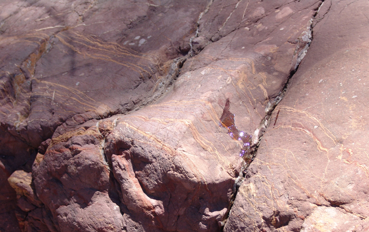
Here below are two further bedrock examples from close nearby, on the left a remarkably tiny whole-circle twist of the rosy-brown [RGB] mudstone (size indicated in relation to the prickly pear pads nearby), and on the right an outcrop of yellow-streaked rosy-brown mudstone. Many clasts of this latter stone stand out visually when seen in alluvial deposits further downstream. (Click on each image to enlarge it.)
 ...
...
The Cascabel Formation
This Formation is composed of some pebble-to-boulder conglomerate, and mostly sandstone with some siltstone and mudstone. It is 75-65 million years in age. Most of this deposition was probably alluvial-fan (bajada) in character, with a drainage toward the south (suggesting that the debris was shed from highlands to the north), and it apparently proceeded even as the Hot Springs Thrust Fault was making its move (see more below).
The thickness of Cascabel deposition suggests a deposition rate of probably about 100 meters thickness per million years during about a ten-million year period. Some of it looks similar to the Willow Canyon Formation, but it seems more diverse, appears to support richer vegetation than does the Willow Canyon (as does the Galiuro Volcanics), and contains some seeps and a spring on our land. (The Muleshoe Spring located just south of our boundary with the Nature Conservancy in section 3 is a fine example of this, and so is our Sierra Blanca Spring.)
Conglomerates are very widespread in the Cascabel Formation in our area. Below, during the November 2002 Geology Walk, David Omick and Mick Meader (rear left and right) stand in front of the the meeting-point of Willow Canyon and Cascabel Formations, their knees roughly marking the boundary. Above is Willow Canyon mudstone; below is Cascabel conglomerate.
Below, a closeup view of some of this conglomerate.


At left, at a point further upstream, Dick Henderson views Cascabel conglomerate boulders that have fallen from the canyon walls above.
Click on the image to enlarge it.
For other parts of Saguaro Juniper lands where Cascabel Formation outcrops may be seen, go to Trip up Pool Wash to the Trail Tank Area and to Cascabel Formation in Sierra Blanca Canyon Wash. For more on these formations see also Geology Walk: 5) Older Patterns.
The overall deposition of materials in relation to the Hot Springs Thrust Fault indicates that this entire faulting process predated the Galiuro Volcanics, since these latter lie undisturbed above it at some points in the area. The Hot Springs Canyon Fault thrusting was due to compressions [as opposed to the much later extensions associated with the block-faulting described above] of the continental crust during the Laramide Orogeny (Rocky-Mountain-formation). Other formations directly reflecting this continental, Laramide mountain-building process in our area include the Muleshoe Volcanics, massive igneous rock formations located mainly NE of our area in the direction of the Muleshoe Ranch (managed by The Nature Conservancy). For one version of the fault relationships in our area, see Hot Springs Canyon X-section
Mick Meader has provided two models of this Hot Springs Canyon Thrust Fault process. First, a general model of a Thrust-slip fault:

Second, a model showing the relationship between the Willow Canyon and Cascabel Formations as the faulting process occurred:

After this compressional process, our region apparently became quiescent for approximately 30-40 million years, since there are no rock formations evident in the vicinity attributable to the Eocene epoch (56-36 million years ago). Then began the era of extreme crustal extension (100% or more), when -- during the late Oligocene-to-Miocene period of mountain building -- detachment faulting (displacement of rocks along faults that dip from less than 35 degrees to nearly horizontal) formed grabens (fault basins) between the Galiuro complex to the east and the Catalina-Rincon complex to the west, synchronous with and following Galiuro Volcanics eruptions beginning about 28 million years ago in late Oligocene times. Basin and Range extension and faulting (with much reduced extensional forces) began about 15 million years ago and continued in this area until about 5 million years ago, and continues today, south of the Chiricahua Mountains, where our most recent strong earthquake was centered in 1887. See Basin-Range.
The following summary time-sequence diagram of Hot Springs Geological History has been compiled by Mick Meader:

Return to Geology Home Page